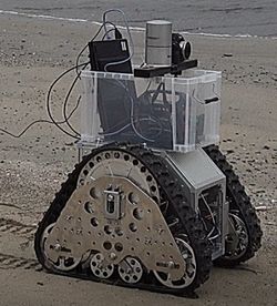
SLAM (Simultaneous Localization and Mapping) system with Four RGB-D cameras
A SLAM (Simultaneous Localization and Mapping) system using four RGB-D cameras (Microsoft Kinect) has been developed. This system captures 3D environmental structures in real-time as the robot moves. For precise localization, CPS-SLAM (Collaborative Probabilistic SLAM) is utilized, and the robot's position is detected by a parent robot using a total station (laser range finder).
| SLAM using four kinect cameras | 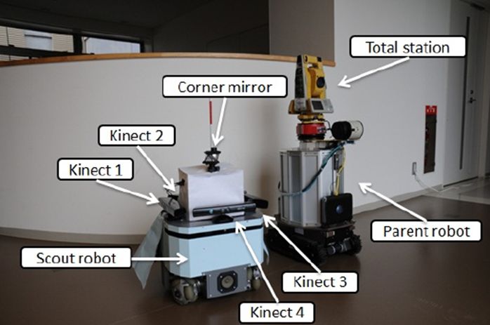 System configuration
 |
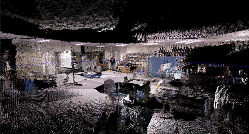 Measurement results
 |
Papers
- R. Kurazume, K. Yoneda, and S. Hirose, Feedforward and feedback dynamic trot gait control for quadruped walking vehicle, Autonomous Robots, Vol. 12, No. 2, pp.157-172, 2002.
- 鄭 龍振, 大石 修士, 倉爪 亮, 岩下 友美, 長谷川 勉, 広域レーザ計測地図とRGB-Dカメラを用いた移動ロボットの大域的3次元位置同定画像の認識理解シンポジウム (MIRU2012), IS2-77, 2012.8.7
- 鄭 龍振, 大石 修士, 倉爪 亮, 長谷川 勉, RGB-Dセンサと3 次元地図を用いたXORボックセルマッチングによる位置同定, 日本機械学会ロボティクスメカトロニクス講演会2012, 2A2-I10, (2012.5.27~29)
- 鄭 龍振, 石橋 正教, 倉爪 亮, 岩下 友美, 長谷川 勉, 4台のKinect を搭載した全方向計測ロボットによる環境計測, 第29回日本ロボット学会学術講演会, 1O3-4, 2011.9.7
Fast 3D localization for mobile robot using Normal Distributions Transform
We propose an efficient 3D global localization and tracking technique for mobile robots in large-scale environments using 3D geometrical maps and RGB-D cameras. With the rapid development of high-resolution 3D range sensors, high-speed processing of large amounts of 3D data is becoming an urgent challenge in robotic applications such as localization. To tackle this problem, the proposed technique utilizes a Normal Distributions (ND) voxel representation. First, a 3D geometrical map represented by point clouds is converted into several ND voxels, and local features are extracted and stored as an environmental map. Additionally, range data captured by an RGB-D camera is also converted into ND voxels, and local features are calculated. For global localization and tracking, the similarity of ND voxels between the environmental map and the sensory data is examined according to the local features or Kullback-Leibler divergence, and optimal positions are determined within a particle filter framework.
| Kinect color image | Kinect depth image | Localization process |
Papers
- 鄭 龍振, 倉爪 亮, 岩下 友美, 長谷川 勉, 大規模な3次元環境地図とRGB-Dカメラを用いた移動ロボットの広域位置同定, 日本ロボット学会誌, Vol.31, No.10, pp.896-906, 2013 (2014年度日本ロボット学会論文賞)
- Shuji Oishi, Yongjin Jeong, Ryo Kurazume, Yumi Iwashita and Tsutomu Hasegawa, ND voxel localization using large-scale 3D environmental map and RGB-D camera, 2013 IEEE International Conference on Robotics and Biomimetics (ROBIO), pp.538-545, Shenzhen, Dec. 12-14, 2013 (Best Paper Award Finalist)
- 鄭 龍振, 大石 修士, 倉爪 亮, 岩下 友美, 長谷川 勉, 広域レーザ計測地図とRGB-Dカメラを用いた移動ロボットの大域的3次元位置同定, 画像の認識理解シンポジウム (MIRU2012), IS2-77, 2012.8.7
- 鄭 龍振, 大石 修士, 倉爪 亮, 長谷川 勉, RGB-Dセンサと3 次元地図を用いたXORボックセルマッチングによる位置同定, 日本機械学会ロボティクスメカトロニクス講演会2012, 2A2-I10, (2012.5.27~29)
Quadcopter Helicopter
We are developing quadcopters and helicopters used for land surveying.
| Helicopter | Helicopter | Helicopter |
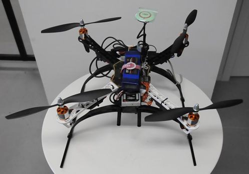 Quadcopter
 |
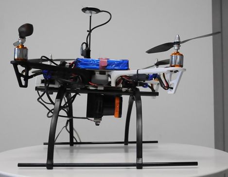 Quadcopter
 |
Laser scanning from quadcopter |
Papers
Spatial change detection using voxel classification by normal distributions transform
Detection of spatial changes around a robot is essential in various robotic applications, such as search and rescue, security, and surveillance. This paper proposes a fast spatial change detection technique for a mobile robot using an on-board RGB-D/stereo camera and a highly precise 3D map created by a 3D laser scanner. This technique first converts point clouds from the map and measured data into grid data (ND voxels) using normal distribution transformation and classifies the ND voxels into three categories. The voxels from the map and measured data are then compared according to these categories and the features of the ND voxels. Overlapping and voting techniques are also introduced to enhance the robustness of spatial change detection. We conducted experiments using a mobile robot equipped with real-time range sensors to validate the performance of the proposed real-time localization and spatial change detection techniques in both indoor and outdoor environments.
 Mobile robot with Kinect
 |
Detected differences | ICRA 2019 Video |
Papers
- Ukyou Katsura, Kohei Matsumoto, Akihiro Kawamura, Tomohide Ishigami, Tsukasa Okada, Ryo Kurazume,Spatial change detection using voxel classification by normal distribution transformation, IEEE International Conference on Robotics and Automation 2019 (ICRA 2019), pp.2953-2959, Montreal, Canada, 2019.5.20-24, 2019
- 桂 右京, 松本 耕平, 河村 晃宏, 倉爪 亮, 石上 智英, 岡田 典, 距離データに対するNDTを用いた高速な差分検出手法の提案 -屋内・屋外環境での差分検出精度の検証-, 日本機械学会ロボティクスメカトロニクス講演会2019, 2A1-R08, 2019.6.5-8
- 桂 右京, 倉爪 亮, 石上 智英, 岡田 典, 距離データに対するNDTを用いた高速な差分検出手法の提案, 第36回日本ロボット学会学術講演会, 3J3-01, 2018.9.5-7
- 桂 右京, 倉爪 亮, 石上 智英, 岡田 典, 距離データに対するNDTを用いた高速な差分検出手法の提案, 日本機械学会ロボティクスメカトロニクス講演会2017, pp.2A2-O08, 2017.5.10-13
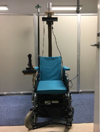
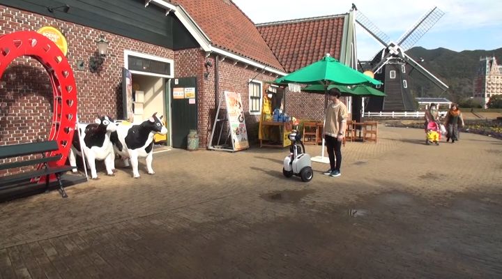
Tour guide robot and personal mobility vehicle
We are developing a tour guide robot and a personal mobility vehicle that utilize not only their embedded sensors but also surrounding sensors placed along streets.
| Personal vehicle | Wheelchair-type personal vehicle |
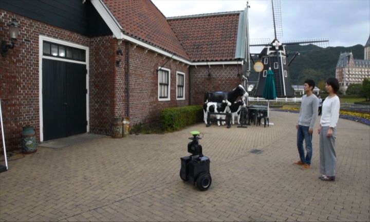 Tour guide robot, Qurin |
 Tour guide robot, Qurin 2 |
| Tuor guide robot | Navigation using QZSS and 5G |
| Real time transmission of 4K 360 degrees video via 5G network | Navigation using LiDAR and 5G |
| Tour guide experiment in theme park | Guide experiment in hospital |
Papers
- Kohei Matsumoto, Hiroyuki Yamada, Masato Imai, Akihiro Kawamura, Yasuhiro Kawauchi, Tamaki Nakamura, Ryo Kurazume, Development of a Tour Guide and Co-experience Robot System using the Quasi-Zenith Satellite System and the 5th-Generation Mobile Communication System at a Theme Park, ROBOMECH Journal, Vol.8, No.4, 2021, DOI:10.1186/s40648-021-00192-7
- Kohei Matsumoto, Hiroyuki Yamada, Masato Imai, Akihiro Kawamura, Yasuhiro Kawauchi, Tamaki Nakamura, Ryo Kurazume, Quasi-Zenith Satellite System-based Tour Guide Robot at a Theme Park, 2020 IEEE/SICE International Symposium on System Integration (SII), pp. 1212-1217, doi: 10.1109/SII46433.2020.9025964, Honolulu, Hawaii, USA, Hawai, USA, 2020.1.12-15, 2020
- Hiroyuki Yamada, Tomoki Hiramatsu, Imai Masato, Akihiro Kawamura, Ryo Kurazume, Sensor terminal "Portable" for intelligent navigation of personal mobility robots in informationally structured environment, 2019 IEEE/SICE International Symposium on System Integrations (SII), Paris, 2019.1.14-16, 2019
- 松本 耕平, 今井 将人, 山田 弘幸, 河村 晃宏, 川内 康裕, 中村 珠幾, 倉爪 亮, 準天頂衛星測位システムを用いたテーマパークにおける案内ロボットシステムの開発, 日本機械学会ロボティクスメカトロニクス講演会2019, 1P1-R10, 2019.6.5-8
- 松本 耕平, 今井 将人, 山田 弘幸, 河村 晃宏, 倉爪 亮, テーマパークにおける自律案内ロボットの開発, 第19回計測自動制御学会システムインテグレーション部門講演会 SI2018, pp.2051-2054, 2018.12.13-15
- Kohei Matsumoto, Masato Imai, Hiroyuki Yamada, Akihiro Kawamura and Ryo Kurazume, Development of Autonomous Tour-Guide Robot System in a Theme Park, Proc. The 14th Joint Workshop on Machine Perception and Robotics (MPR18), PS4-7, Fukuoka, 2018.10.16-17
- 今井 将人, 平松 知樹, 山田 弘幸, 河村 晃宏, 倉爪 亮, パーソナルモビリティのための情報構造化環境の構築とテーマパークでの誘導実験, 日本機械学会ロボティクスメカトロニクス講演会2018, pp.2A2-D07, 2018.6.2-5
- 平松 知樹, 今井 将人, 山田 弘幸, 河村 晃宏, 倉爪 亮, 小型センサ端末によるパーソナルモビリティ・ビークルの誘導制御システムの開発, 日本機械学会ロボティクスメカトロニクス講演会2018, pp.1A1-L10, 2018.6.2-5
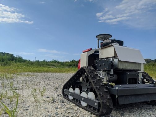
Autonomous lawn-mowing robot
We develop an autonomous lawn-mowing robot equipped with QZSS MICHIBIKI for centimeter-level positioning using CLAS and 3D-LiDAR for obstacle detection. For automatic planning and motion control toward multiple targets, we adopted Navigation2 in ROS2.
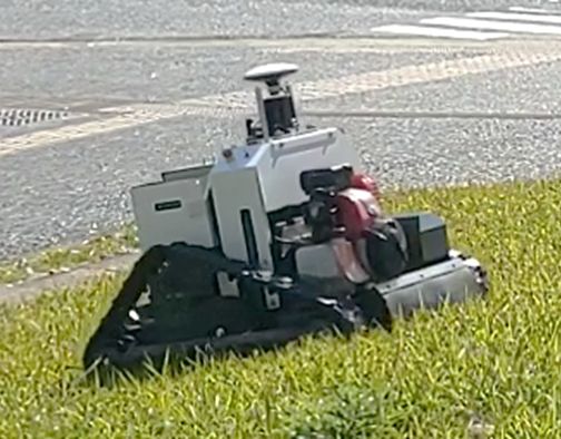 1st model autonomous lawn-mowing robot |
 2nd model autonomous lawn-mowing robot |
Papers
Automatic illuminance measurement multiple robots
We develop an automatic illuminance measurement multi-robot to check lighting conditions in large warehouses. This robot uses advanced sensors and algorithms to ensure optimal illuminance levels across extensive areas, promoting energy efficiency and safety.
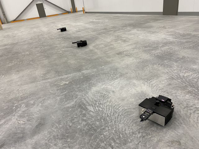 Measurement by automatic illuminance measurement multiple robots |
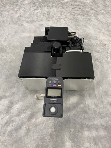 Automatic illuminance measurement multiple robots |
| Illuminance measurement | Illuminance measurement |
Papers
Beach cleaning robot
We develop a beach cleaning robot to collect microplastic debris. The aim is to tackle the pervasive issue of microplastic pollution in marine environments, ensuring cleaner and safer beaches for all living beings.
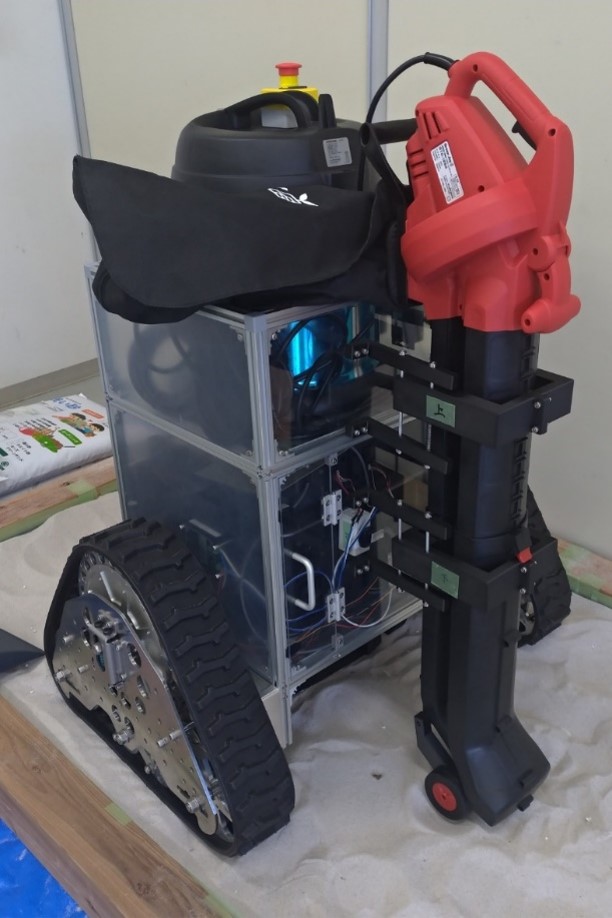 Beach cleaning robot |
 Beach measurement robot |
| Beach cleaning | Beach cleaning |
Papers
- 海洋破砕プラスチックごみ回収ロボットの開発
宇野 光輝, 倉爪 亮
第23回計測自動制御学会システムインテグレーション部門講演会 SI2022, 1A2-D04, 2022.12.14-16 [pdf][bibtex] - 海洋破砕プラスチックごみ回収ロボットシステムの開発 -レーザースキャナの反射輝度によるごみ検出とロボットの誘導-
有瀬 昌矢, 松本 耕平, 倉爪 亮
第23回計測自動制御学会システムインテグレーション部門講演会 SI2022, 1A2-D11, 2022.12.14-16 [pdf][bibtex] - 海洋破砕プラスチックごみ回収機構の開発
宇野 光輝, 倉爪 亮
第22回計測自動制御学会システムインテグレーション部門講演会 SI2021, 1H4-03, 2021.12.15-17 [pdf][bibtex] - 海洋破砕プラスチックごみ回収ロボットシステムの開発 レーザスキャナの反射輝度を用いた海岸環境の識別
有瀬 昌矢, 倉爪 亮
日本機械学会ロボティクスメカトロニクス講演会2021, 1P2-G09, 2021.6.6-8
[pdf][bibtex]
Construction robot
We develop a retrofit-type remotely controlled backhoe, a compaction evaluation method for vibratory rollers using the multi-sensor terminal "Sensor Pod," and a Cyber Physical Platform for construction sites called "ROS2-TMS for Construction."
| A retrofit-type remotely controlled backhoe | 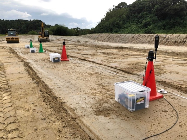 Compaction evaluation experiment by vibratory rollers using Sensor Pods |
Papers
- Evaluation of ground stiffness using multiple accelerometers on the ground during compaction by vibratory rollers
Yusuke Tamaishi, Kentaro Fukuda, Kazuto Nakashima, Ryuichi Maeda, Kohei Matsumoto, Ryo Kurazume
40th International Symposium on Automation and Robotics in Construction (ISARC 2023), pp. ,doi:, Chennai, 2023.7.4-7, 2023
[pdf][bibtex] - 土木工事における地盤剛性評価・安全管理のための分散型センサポッドの開発
福田 健太郎, 中嶋 一斗, 前田 龍一, 松本 耕平, 倉爪 亮
第23回ロボティクスシンポジア, , 2023.3.15-16 [pdf][bibtex] - レトロフィット型バックホウ遠隔操縦システムの開発 -第2報 操作性の向上と後付センシングシステムの開発-
柴田 航志, 西浦 悠生, 倉爪 亮
第23回計測自動制御学会システムインテグレーション部門講演会 SI2022, 3P2-G17, 2022.12.14-16 [pdf][bibtex] - 多点同期振動データの波形歪みに基づく地盤剛性評価手法の提案
福田 健太郎, 中嶋 一斗, 倉爪 亮
第20回 建設ロボットシンポジウム, P2-2, 2022.8.24-25
[pdf][bibtex] - 多様な環境に適応しインフラ構築を革新する協働AIロボット(土工を革新するハードウエアと現場を俯瞰するセンサポッドシステムの紹介)
永谷圭司, 大須賀公一, 竹囲年延, 倉爪亮
第4回 i-Constructionの推進に関するシンポジウム, pp.115-118, 2022.7.11
[pdf][bibtex] - レトロフィット型バックホウ遠隔操縦システムの開発
西浦 悠生, 中嶋 一斗, 倉爪 亮
日本機械学会ロボティクスメカトロニクス講演会2022, 1P1-C07, 2022.6.1-4
[pdf][bibtex] - 転圧地盤評価のための分散型センサポッドの開発 -第2 報多点同期振動データの波形歪みに基づく地盤剛性の定量化-
福田健太郎, 中嶋 一斗, 倉爪 亮
日本機械学会ロボティクスメカトロニクス講演会2022, 1A1-E04, 2022.6.1-4
[pdf][bibtex] - 転圧地盤評価のための分散型センサポッドの開発
福田 健太郎, 中嶋 一斗, 倉爪 亮
第22回計測自動制御学会システムインテグレーション部門講演会 SI2021, 3H4-05, 2021.12.15-17 [pdf][bibtex]